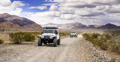
Looking for the best navigation app to guide you through the trails on your next adventure? These apps will help you explore new trails with confidence.
The top picks for the best off-road navigation apps include Gaia GPS, Google Maps, onX Offroad, Avenza Maps, and ViewRanger. These apps offer a range of features, including offline maps, real-time weather updates, trail conditions, and more.
Whether you're an experienced off-roader or a novice, having a reliable navigation app is essential to ensure that you stay on track and avoid getting lost in the wilderness. Based on my experience and research from verified end-user reviews, I’ve compiled the best off-road navigation apps to help you confidently explore the wilderness. Read on to find the best off-road navigation app that suits you best.
Key Takeaways
- Look for an app that offers a variety of features to enhance your off-road experience.
- Consider customizable and offline maps, trail tracking, and real-time weather updates.
- Look for an app with a user-friendly interface that is easy to navigate.
- Lastly, while some apps are free, others require a subscription or a one-time fee.
This article may contain affiliate links where we earn a commission from qualifying purchases.
Best Off-Road Navigation Apps
If you're an off-road enthusiast, having a reliable navigation app can make all the difference in your adventures.
You don’t want to lose access and get stranded in the middle of the wilderness because you don’t have a reliable navigation app. With the right app, you can plan your own routes, track your progress, and stay safe on the trail.
Here’s a quick summary of the top-rated off-road navigation apps to check out:
1. Gaia GPS
If you're looking for an off-road navigation app that offers off-road maps and trails for Overlanding, 4x4, OHV, and ATV, Gaia GPS is an excellent choice.
This app provides you with the best trail maps for your off-road adventures, allowing you to plan your Overlanding expeditions prior as well as discover new interesting camping spots with ease.
Features
- Access to more than 250 maps, including USGS Topo, NatGeo Trails Illustrated, and MVUM
- Ability to download maps for offline use
- Customizable trail map layers and overlays
- Tracking and recording your route, distance, and elevation
- Real-time weather updates
- Integration with wearable devices
How It Works
Gaia GPS works by using your device's GPS to track your location and provide you with real-time updates on your route, distance, and elevation.
Gaia is a must-have app because it’s one of the most efficient downloadable apps available. Downloading maps for offline use is particularly useful when you're in an area with limited cell service. The app also has awesome features that allow you to customize your map layers and overlays to see the information that's most important to you.
What Sets It Apart
Its extensive library of maps sets Gaia GPS apart from other off-road navigation apps. With access to more than 250 maps, including USGS Topo, NatGeo Trails Illustrated, and MVUM, you're sure to find the map you need for your next off-road drive.
Pros
- Extensive library of online and offline maps
- Customizable map layers and overlays
- Ability to download maps for offline use
- Real-time weather updates
- Integration with wearable devices
Cons
- Some users have reported issues with the app crashing
- It can be expensive for some users
2. Google Maps
If you like off-road driving and are looking for a reliable and easy-to-use navigation app, Google Maps is a great option for off-road navigation. With its extensive mapping data and user-friendly interface, Google Maps is a popular choice for both casual and experienced off-road enthusiasts.
Features
One of its most useful features is its ability to provide real-time traffic updates, which can help you avoid congested areas and save time on your journey.
It also offers turn-by-turn directions, voice-guided navigation, and the ability to search for nearby points of interest, such as gas stations, restaurants, and hotels.
How It Works
It uses GPS technology to track your location and provide accurate directions. You can enter your destination address or search for a point of interest, and the app will provide you with the best route to get there.
It also offers satellite and street views, which can help you better understand your surroundings and navigate more effectively.
It's particularly well-suited for those who are traveling in urban or suburban areas but may not have as much detail on off-road hiking trails as some other navigation apps.
What Sets It Apart
One of the key advantages of Google Maps is its extensive mapping data. With coverage in over 200 countries, it offers one of the most comprehensive mapping solutions on the market.
It also integrates with other Google services, such as Google Search and Google Earth, making it a versatile tool for exploring new areas and finding interesting places to visit.
Pros
- Extensive mapping data
- Real-time traffic updates
- Turn-by-turn directions
- Voice-guided navigation
- Search for nearby points of interest
Cons
- Requires an internet connection to access mapping data
- It may not have as much detail on trails as other navigation apps
3. Topo Maps
If you're looking for a reliable off-road navigation app, you need one that offers detailed topographic maps.
These maps show contour lines, elevations, and terrain features. Here's all you need to know about the Topo Maps feature in the best off-road navigation apps:
Features
The Topo Maps feature in off-road navigation apps provides detailed topographic maps that are essential for planning and navigating off-road trips.
These maps show the elevation, contour lines, and terrain features, allowing you to plan your route and navigate terrains with ease.
You can also use the Topo Maps feature to track your progress and record your route for future reference.
How It Works
The Topo Maps feature in off-road navigation apps works by using GPS technology to track your location and overlaying that information onto a topographic map.
The app allows you to see your location in relation to the terrain features around you, making it easier to navigate off-road terrain. If you're an avid off-roader or outdoor enthusiast, an off-road navigation app with Topo Maps is a great investment.
What Sets It Apart
What sets the Topo Maps feature apart from other mapping features is its level of detail. Topographic maps provide a level of detail that other maps simply can't match, making them essential for off-road navigation. Topo Maps can also be used offline, which is crucial when you're out of cell range.
Pros
- Provides detailed topographic maps
- It allows you to plan your route and navigate with ease
- Unlike Google Maps, Topo Maps can be used offline
Cons
- It may require a subscription or in-app purchase
- Maps can take up a lot of storage space on your device
- It can be difficult to read in low-light conditions
4. Avenza Maps
If you're looking for an app that offers offline mapping for off-road driving, Avenza Maps is a great option.
This app features maps from National Geographic, national parks, and more, so you can stay on track with GPS even when you're offline. Here's what you need to know about the app:
Features
- Access maps from a variety of sources, including National Geographic, national parks, and more
- Use GPS to stay on track even when you're offline
- Import your own geospatial PDF, GeoPDF, and GeoTIFF maps
- Add shapefiles directly to your map to see even more data
How It Works
Avenza Maps uses your device's GPS to track your location and display your position on the map. You can download maps for offline use, so you don't need an internet connection to use the app.
When you're offline, the app will still track your location using GPS, so you can navigate even when you're in areas without cell service.
Whether you're looking for maps from National Geographic, national parks, or other sources, this app has you covered.
What Sets It Apart
What sets Avenza Maps apart from all the apps is the ability to import your own geospatial PDF, GeoPDF, and GeoTIFF maps. This means you can use maps you've created or downloaded from other sources to customize your maps to meet your needs.
Pros
- Offers offline mapping for off-road adventures
- Access to maps from National Geographic, national parks, and more
- Import your own geospatial PDF, GeoPDF, and GeoTIFF maps
- Add shapefiles directly to your map to see even more data
Cons
- Some features require a subscription
- Not all maps are free
5. GPS Waypoints Navigator
If you're looking for an off-road navigation app that offers a variety of features and tools, GPS Waypoints Navigator is worth considering.
This app is designed to help you easily navigate back-country, waterways, and roadways. Here's what you need to know about this app.
Features
- Offline maps
- Customizable waypoints and routes
- Tracking and recording capabilities
- Compass and bearing information
- Multiple coordinate formats
- Integration with Google Maps
How It Works
The app uses road GPS to track your location and provide real-time information about your surroundings.
You can customize your routes and waypoints to fit your specific needs, and the app will provide you with turn-by-turn directions to help you reach your destination.
If you're an off-road enthusiast who enjoys exploring new places, GPS Waypoints Navigator is a great tool to have. It's a great option for hikers, hunters, and anyone else who needs a reliable navigation app for hiking trails or other outdoor activities.
What Sets It Apart
One thing that sets GPS Waypoints Navigator apart from other off-road navigation apps is its customizable features.
You can create your own maps, routes, and waypoints, and the app will provide detailed information about each. Additionally, the app offers a few features that allow coordinate formats, so you can choose the one that works best for you.
Pros
- Customizable maps and waypoints
- Offline maps
- Multiple coordinate formats
- Integration with Google Maps
Cons
- Some users have reported issues with the accuracy
- The app can be difficult to navigate at first
- Some features are only available in the paid version
6. BackCountry Navigator XE
If you're looking for a reliable off-road navigation app, BackCountry Navigator XE is definitely worth checking out.
This app has a lot of great features that make it a popular choice among outdoor enthusiasts. Here's what you need to know about it:
Features
- Topographic maps
- Offline maps
- GPS tracking
- Waypoints
- Marking trails and routes
- Compass and bearing tracking
- Customizable map layers
How It Works
BackCountry Navigator XE is easy to use. Simply download the app, choose your map layers, and start navigating.
You can mark all the trails and routes, add waypoints, and track your progress with GPS. The app also works offline, so you can use it even when you don't have a signal.
If you're an outdoor enthusiast who enjoys hiking, camping, or off-roading, BackCountry Navigator XE is a great app to have.
What Sets It Apart
BackCountry Navigator XE is different from other off-road navigation apps due to its customizable map layers. You can choose from a variety of topographic maps and add your own custom layers, making it easy to find the information you need.
Pros
- Easy to use
- Offline maps
- Customizable map layers
- GPS tracking
- Waypoints
Cons
- Some users have reported issues with the app crashing
- The app can be a bit slow in loading maps
7. onX Offroad
If you're looking for a reliable off-road navigation app or road GPS app, onX Offroad is one of the best options available. Here's a closer look at what it has to offer:
Features
onX Offroad navigation app offers more than 550,000 miles of open roads and trails, plus 985 million acres of public land through detailed interactive maps.
Some of its key features include:
- Access to features nationwide, including Featured Trails, custom waypoints, offline maps, tracking
- Property boundaries and landowner names
- Acreage information
How It Works
The onX Offroad app uses GPS mapping to help you navigate off-road trails. You can search for trails by location, difficulty level, and more. You can also save and share your favorite trails and even create your own custom maps with waypoints and notes.
With this app, you can easily find all the off-road trails you want to explore, whether you’re looking to discover what's open nearby or check out somewhere new.
What Sets It Apart
One thing that sets onX Offroad apart from other off-road navigation apps is its extensive trails and public lands database.
It also offers detailed maps and property information, which can be especially helpful for hunters and outdoor enthusiasts.
Additionally, onX Offroad is available for both iOS and Android devices, making it accessible to a wide range of users.
Pros
- Extensive database of trails and public lands
- Detailed maps and property information
- Available for both iOS and Android devices
- Customizable maps with waypoints and notes
Cons
- Requires a subscription to access all features
- It may not have as many user-generated trails as some other apps
8. Polaris GPS
If you are an off-road enthusiast looking for a reliable GPS navigation app, Polaris GPS may be just what you need.
This app is designed specifically for off-road adventures and offers a range of features to enhance your experience. Let’s take a closer look at what Polaris GPS has to offer.
Features
- GPS tracking to help you stay on course
- Offline maps, so you can navigate even when you don't have a signal
- Trail maps, including detailed information on popular off-road trails
- Customizable waypoints and routes, so you can plan your own adventure
- Real-time weather updates, so you can plan your ride accordingly
How It Works
The Polaris GPS app is easy to use. Simply download the app, create an account, and start exploring. You can search for trails, save your favorite routes, and even share your adventures with others.
The app uses GPS technology to track your location and provide turn-by-turn directions. You can also customize the app to show you the information you need most, such as speed, elevation, and distance traveled.
What Sets It Apart
What sets Polaris GPS apart from other navigation apps is its focus on off-road adventures. From trail maps to weather updates, Polaris GPS has everything you need to plan and execute your next off-road adventure.
Pros
- Easy to use and navigate
- Customizable maps and routes
- Real-time weather updates
- Offline maps, so you can navigate even when you don't have a signal
Cons
- The app is only available for iOS devices
- Some users have reported issues with the accuracy
- The app can be slow to load at times